Soil survey is a major occupation of soil scientist.
Soil survey also called soil mapping, is defined as the process of classifying soil types and other soil properties in a given area and geo-encoding such information.
It is an important task because soils do not normally have sharp boundaries but gradually grade from one into another. This grading is determined by inspection pits or auger holes.
Soil survey provide information on the soil type of an area and special distribution of individual soil types and characteristics of individual soil types from a morphological, chemical and mineral properties. And also, the correlation of individual soil data and interpretation of information collected as well as recommendation. Soil survey provides both qualitative and quantitative data for land use.
PURPOSE OF SOIL SURVEY
Soil survey is carried out by mapping of the area needed for survey. The purpose of mapping may be a special or general purpose survey.
GENERAL PURPOSE SURVEY: In this survey the soils are mapped according to their morphology
SPECIAL PURPOSE SURVEY: In this survey, the mapping is restricted and specific number of properties are mapped. For example, irrigation or degree of salinity
IMPORTANCE OF SOIL SURVEY
1. The information in a soil survey can be used by farmers and ranchers to help determine whether a particular soil type is suited for crops or livestock and what type of soil management might be required.
2. An architect or engineer use the engineering properties of a soil to determine whether it is suitable for a certain type of construction.
3. A homeowner use soil survey information for maintaining or constructing their garden, yard, or home.
4. Soil survey information can be used to predict or estimate the potentials and limitations of soils for many specific uses.
5. It is used to make predictions. That is to determine the important characteristics of the soil.
6. It is used for soil classification
7. It is used to correlate and predict the adaptability of soils to various soil types
8. It is used to aid farm planning in relocating field boundaries inorder to make field more uniform.
9. It is used for land appraisal
10. It is also used for loan appraisal
TYPES OF SOIL SURVEY
There are six major types of soil survey based on mapping scale. They include:
1. Exploitatory survey
2. Reconnaissance survey
3. Semi scale survey
4 detailed survey
5 intensive survey
6. Compilation survey
1. EXPLOITATORY SURVEY : Information from data provide information about a continent and sufficient detail of generalised term with scale 1:5, 000,000 units. It shows the group of soil in relation to general land forms. It also aid investigation and planning for natural atlas, teaching and other background information. The scale is very small.
2. RECONNAISSANCE SURVEY : This provide information for a much more smaller area. It’s mapping scale is 1:25000. The mapping units are mostly land form, other mapping units include the land system. It provides information on systematic basis for national soil classification and identification of project types.
3. SEMI SCALED SURVEY : The map is scaled at 1: 50,000. The soil mapping scale is usually soil association such as parent materials. It is used for visibility studies of various developmental projects. It provides information for various land use planning
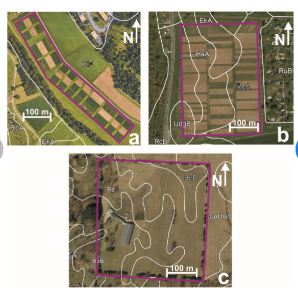
4 DETAILED SURVEY : This provide map at 1:25, 000,1:20,000, 1:10,000. It closely define soil units such as soil series or phases. The soil classification under detailed survey is ideal for agricultural advisory form, for irrigation, and pre-urban soil survey. It is costly and time consuming.
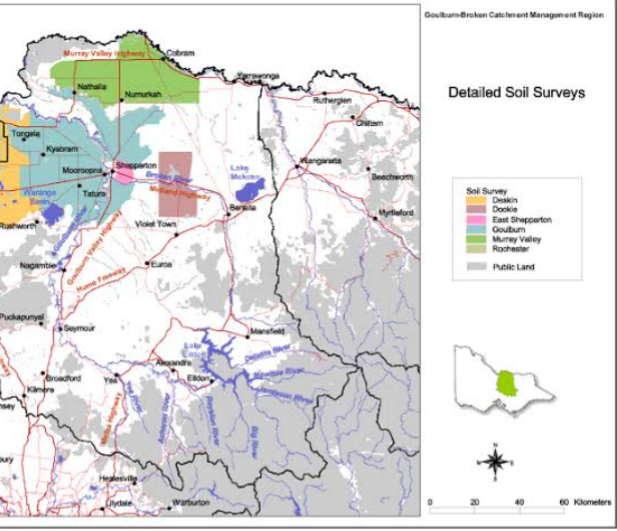
5 INTENSIVE SURVEY : This provide information and map scale larger than 1:10, 000. It is used mainly for agricultural experimental projects. For example, land capability, and soil suitability for research information
6. COMPILATION SURVEY : This are soil maps based on abstraction from other surveys. The scales are usually 1,000,000 or smaller
METHOD OF SOIL SURVEY AND PROCEDURES
Soil survey usually takes months and years to complete. It requires expenses, careful planning, getting suitable staffs, equipment, accommodation, transportation, maps, and laboratory facilities.
The method of the soil survey depends on
a. types of soil survey
b. Nature of the area whether forest or grassland and
c. Available information about the area. For example, road network, area photograph and topographical map.
d. Aims and objectives of the soil survey
e. The soil mapping scale
f. Personnel availability
On the basis of the soil mapping scale, soil survey can range from preliminary survey to reconnaissance to very detailed and intensive reconnaissance survey.
There are three stages of soil survey. They include pre-field preparation, field preparation and post field preparation.
PRE-FIELD PREPARATION OF SOIL SURVEY
This is the collation and study of the existing data of an area. That is, maps, reports, top-sheets and analytical data, general field reconnaissance, aerial photoassemblage and interpretation, and design and planning of the field survey.
FEILD SURVEY
Field survey involves initial reconnaissance survey, then followed by details of the area and soil sample at regular interval. During reconnaissance survey, the entair area would be completely transverse through major and minor foot paths . Changes in the land or slope could be observed and auger boring could be observed and described at some points in the various land units. A number of soil sampling units could be identified to serve as reagent for more detailed survey.
The field map is then submitted to the drawing office for the preparation of the final coloured map and it’s accompaning legend.
POST FIELD SURVEY OPERATION: this is the revision of the aerial photo interpretation in the light of field observation. The soil samples collected are analysed. The survey report is written. The unit of mapping is usually the soil series.
LIMITATIONS OF SOIL SURVEY
1. Reconnaissance soil surveys are best suited to making general comparisons of soil capabilities and limitations on a regional, national or even worldwide scale. They are not reliable for making on-farm decisions as they lack the detail necessary to describe the variation in the soil types on the farm.
2. To carry out soil survey is highly cost effective. Tools and equipment used for the survey are expensive.
3. The reliability of the field data and its interpretation is largely dependent on the experience and ability of the survey or the surveyor.
4. Soil survey expertise are scarce, data collection by less experienced individuals should always follow standardized procedures and should only be carried out by those who have received training in soil survey.
5. Soil survey data seldom contain detailed, site specific information.
AERIAL PHOTOGRAPH
The initial part of survey usually start with an examination of the aerial photographs of the area and from which preliminary boundaries may be drawn then checked by field examinaters.
AERIAL photograph is a picture of the land surface taken from the air and engraved to negatives then transfered to metal plates. Or, they are pictures produced from photographic negatives in the air. They are then transfered to the metal plate and engraved. Aerial photographs have a number of advantages, particularly with regards to finding ones location. Aerial photographs have a varying scale across the photographs, therefore, they cannot be used as complete substitutes for maps. The scale of the map varies from the FAO/UNESCO world soil map at 1:5,000,000 to as large as 1:10,000 for detailed maps in which individual fields are shown.
PHOTOGRAMETRY: This is the measurement of light. It is an image of the land surface with difference in the surface reflection of light appearing as differences in torn (black, white and grey torns). The photographs are taken in pairs because the photographs are not uniform in plan. The photographs taken by helicopters must overlap moderately to view all areas.
USES OF AERIAL PHOTOGRAPHS
1. In the past, ARIAL photograph was used mainly for recognisance survey ( study of a very large area).
2. In countries with very little informations on soil survey employ ARIAL photographs for detailed work.
3. Developed countries use ARIAL photograph like an augar.
4. Aerial photography is useful both for regional analysis and for evaluating specific sites.
5. It can provide a historical perspective that allows us to view changes in landscapes overtime.
6. Aerial photographs can be taken from balloons, kites and even pigeons. This are inexpensive method. The use of airplanes, drones and satellites are expensive methods of taking aerial photographs for soil survey.

REMOTE SENSING: In the 60s, satalites are used to produce ARIAL photographs and Quasii (not real) imagery at a very large scale. This photography covers a very large area like regions and continents. The informations produced where so small and produced at Exploitatory scales especially for production of national atlasses and other regional information.
LIMITATIONS OF ARIAL PHOTOGRAPHS
Subsurface features cannot be sensed like soil colour, moisture, texture, types of parent materials and other properties used to differentiate the soil in the field.
IMPORTANCE OF ARIAL PHOTOGRAPH
1. It is used for production of base map
2. It is used for drawing of provisional boundaries
3. It is used to plan field operations such as root transverse, sampling density and other important site.
4. It is used to find routes or pathways easily on field
5. It is used for reversion of post-field interpretation
6. It is used for final presentation of soil map.
PROPERTIES OF AERIAL PHOTOGRAPH
1. Aerial photograph scale is not always correct and constant across the photograph or photo print but usually more accurate towards the centre. For example, relief or hill top will appear to be close to the valley
2. The photograph may be affected by aircraft tilt
3. Air photo interpretation for field use can be treated as base map thus reducing the expense of surveying
4. The photos is also important for transfer of boundaries
5.through steroscopic viewing of adjacent pair, a enormous increase in information can be achieved
6. The photographs are produced in pairs which overlap and under the steroscopic, all areas can be viewed.
AIR PHOTOGRAPH INTERPRETATION
Interpretation depends on difference in variation in torn, texture, pattern and shape.
TORN: This is the shade of grey ( varying from black to white). As a result of this variation, the land features are identified. If there is a bear land, or bed rock, the torn will be white.
WET SOIL: Dark torn
CARNIVOROUS FOREST (HUGE FOREST) WITH TALL TREES: the torn appearance differ. It appears as broad leaf weeds.
WATER, RIVERS, OCEANS, LAKES etc: Are dark as they absorb light
TEXTURE: This is the final pattern of torn and they are reflected as small scale. For example, bear mud flats on a flat plan gives a very smooth texture
FOREST CANOPY WITH DIFFERENT HIEGHT: Gives a moderately rough texture
CROP CULTIVATED AREAS: For example grassland will be different from maize land and orchids.
PATTERNS: This is the irregular variation in torn at which the individual elements can be seen. The variation is so regular. In an orchid compared to bear land, orchid have a particular pattern and bear land have different pattern, termite Hill will give different pattern.
SHAPE: This is the repetition of individual features as pattern. For example, relief can be visible in photographs and to they assist with photo interpretation as they consist of relative height difference between the area covered by overlap of a single steroscopic pair with ground controlled height.
BASIS OF PHOTOGRAPH INTERPRETATION
Since the image of the land surface is an indication of the soil type, photo interpretation is based mainly on the land form, vegetation, land use, and the torn of bear soil and man made structures like buildings, canals and dams.
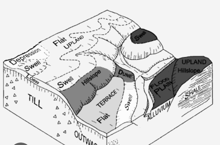
LANDFORMS: This are geomorphic units such as basins, mountains, coastal plains etc. Relief units, undulating plan, long steep slopes, eluvial plan ( different deposit near streams).
LAND SYSTEM: This is the grouping of soils based on topography. This grouping is done in areas with repeating topographic patterns.
DESCRIPTION OF RELIEF UNITS: One of the importance of air photography is steroscopic. Therefore, the drainage spaces, slope distribution, plain forms ( degree of orientation on the plain) and height distribution describe the relief units.