The soil is the topmost layer of the earth’s crust mainly composed of organic minerals and underlying rock that support life. A soil profile is a vertical cross-section of the soil, made of layers running parallel to the surface. It is a vertical phase of a pedon consisting of various horizons and layers. Each profile occupies a volume and space. Therefore, it is also referred to as three dimensional body consisting of lenght, breath and depth. This body have an indefinite lower boundary where it grades or comes in contact with non soil or the bed rock. It also has a less distinct perimeter of layer where it meets other soil or deep water or baring rocks or ice.
Soil is a dynamic system that forms equilibrium with the environment. It is an open system or dynamic system. Soil solution is constantly changing in response to the environment. For example, nutrient uptake, weathering, absorption and discription reaction, leaching, change in moisture content and Soil profile as vertical exposure of soil sequence or layer. At each location of the land, a particular combination of soil forming factor result in formation of different layers.
SOIL PROFILE FORMATION
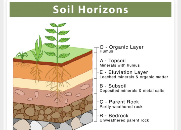
During soil formation, soil profile develops over time as the result of the weathering of minerals and deposition of organic matter. The soil formed are arranged in layers or horizons . These layers or horizons are known as the soil profile. These layers of soil can easily be identified by the soil colour and size of soil particles.
During weathering of the underlying bed rock, parent materials are formed which are called rigolith. This parent material form the C horizon which is the layer below the B horizon and above the R horizon. It consists of slightly weathered rocks, roots of the plants cannot penetrate in this layer. The Regolith is inorganic and lies like a blanket over unfragmented rock. They includes all of the weathered material within the profile. The regolith has two components: the solum and the saprolite. The solum includes the upper horizons with the most weathered portion of the profile. The saprolite is the least weathered portion that lies directly above the solid, consolidated bedrock but beneath the regolith. Further weathering of the C horizon develops to form the B horizons and then the E Horizon and lastly the A horizons.
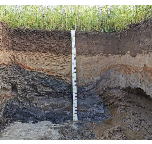
THE HORIZONS
MASTER HORIZONS AND SURBORDINATE HORIZONS
The soil master horizons or layers are symbolized by O, A, E, P, C, and R. For the bed rock, R is used. These master horizons are identified by capital letters. There is subordinate horizon. The Subordinate divisions of master horizons are named by adding lower case letters, for example, Ap, Bt, and Cr. They reflected as lower case a, b, c, d, e, f…… etc. The master horizon or layers reflect the influence of major soil forming factors.
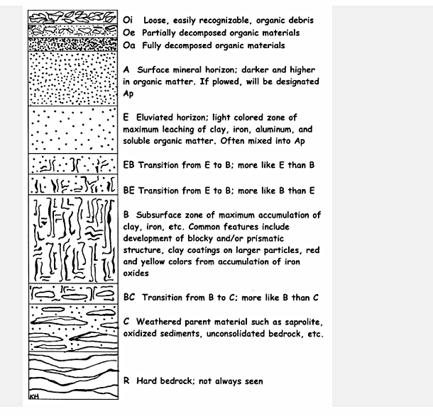
O HORIZON : These are organic horizons usually above the mineral soil or the inorganic material or profile. They are derived from dead plants and animal residues. They are usually absent in grass land regions. They occur usually in forest areas and are usually refer to as forest floor. They are also subdivided into the following subordinate horizons: Oi (slightly decomposed organic matter), Oe (moderately decomposed organic matter), and Oa (highly decomposed organic) . They decay faster.
Oi (Litter) : This is the organic horizon of fabric materials with recognizable plants and animal remains. It is most prominent in forested areas where there is the accumulation of debris fallen from trees.
Oe ( fermentation layer) : This layer consist of hemic materials, highly fragmented residues or intermediate decomposed materials. It still has some recognizable fibro material when crushed between the thumb and fingers.
Oa (humified layer) : This layer contains highly decomposed humic materials, smooth with fine hermophose residues and no recognizable tissue structure.
A HORIZON : This is the top most mineral horizon in most soil containing partially decomposed humified organic matter to give the soil a colour darker than the lower horizon. It consists of minerals (sand, silt, and clay) and with appreciable amounts of organic matter. It is often rough or coarse in texture, having lost some finer materials by translocation to lower horizon either by leaching or erosion respectively
E HORIZON (Eluviation horizon) : this is the zone of maximum leaching of clay and iron and aluminum oxides. It has concentration of resistance minerals like quartz, sand and sometimes silt size. The horizon is typically light in color. It is usually found underneath the A horizon and litter horizon. Therefore, it is referred to as Alpic horizon of the USDA classification.
B HORIZON ( illuvial horizon) : This horizon can be below O, A, and E horizons having undergone sufficient changes due to soil genesis that the original parent material structure is no longer seen. In humid region, there is maximum accumulation of fine materials such as iron and aluminum oxides and silicate clays. This materials may have shallow A horizon which are parts of the B horizon which may be incorporated into the shallow A horizon.
C HORIZON (unconsolidated parent materials) : This is underneath the solum ( Horizon A combined with B). This is below the zone of greatest biological activities and this zone is not sufficiently altered by soil formation to qualify for B horizon . It is loose enough to be dug with a shovel. It retains some features of the structure of the parent rock or the geological deposite from which it is formed. It’s upper layer may atimes become part of the solum as weathering and erosion continues. It is the least weathered horizon. Also known as the saprolite, it is unconsolidated, loose parent material.
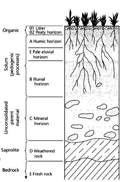
R HORIZON (ROCK) : These are consolidated rocks with little evidence of weathering.
Subdivision within Master horizon include:
k sub horizon: accumulation of sodium
O subhorizon: residue accumulation of sesquioxides (Al2O2. Fe2O3)
p subhorizon: ploughing or other disturbance
q subhorizon: accumulation of silicates
r subhorizon: weathering or soft bed rock
s subhorizon: illuvial accumulation of sesquioxide
t subhorizon: accumulation of silicate clay
v subhorizon: plinth it’s (humus poor and rich in iron)
n. Subhorizon: colour or structure development
x subhorizon: fragipan ( hardened layer, A horizon)
y subhorizon: accumulation of gypsum
x subhorizon: accumulation of salt more soluble than gypsum
ASSESSMENT OF THE HORIZONS WITHIN THE SOIL PROFILE
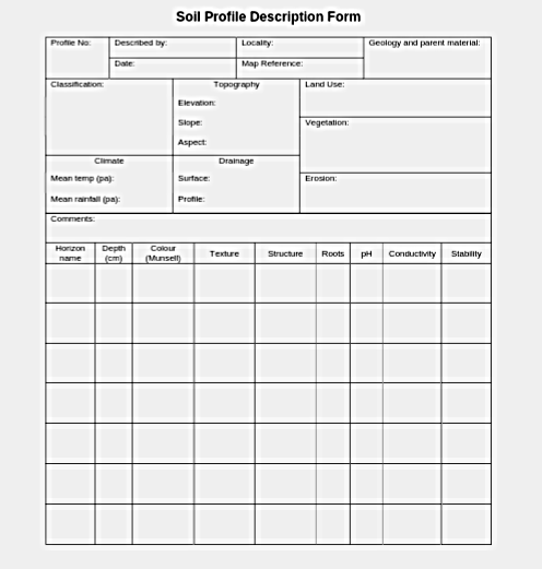
To study the different horizons of the soil profile, soil scientists usually dig a soil pit. A soil pit is a hole that is dug in the soil to assess soil properties. Soil pits can be used to evaluate soil conditions such as: Horizon depths, Texture,
Root density, Colours, Rock fraction and Soil type
SOIL PROFILE STUDY AND MORPHOLOGICAL DISTRIBUTION
Morphological characteristics are properties used to study the soil in the field, that is, natural environment. This properties will assist with the classification of the soil. Morphological characteristics do emphasis on the environmental features of soil formation such as landforms, slopes, vegetation, climate and geology etc.
General information on sites and soils, gives discription of soil profile and the horizons.
STUDY OF SOIL PROFILE
To study the soil profile, information such as
1. Information on the site
2. General information of the soil
3. Brief description of the profile
4. Description of the horizons
are needed.
1. INFORMATION ON THE SITE : This include the location, eluviation (height above sea level), landforms, slope, vegetation, and climate. This will provide enough information of the site.
2. GENERAL INFORMATION OF THE SOIL: To provide general information on the soil, informations like parent material, drainage, moisture condition, ground water table, stonliness, erosion status, texture, salinity and human influence are needed.
3. BRIEF DESCRIPTION OF THE PROFILE:
Demacation of the horizon using knife, then general description can be carried out.
4. DESCRIPTION OF THE HORIZONS :
Properties that change with depth should be used to describe the horizons. For example, depth, colour, texture, structure, and consistency etc.