The soil is composed of minerals, organic matter, air and water. The minerals particles which are cemented together by cementing agents leave spaces between them to form the soil skeleton. This spaces which form network of interconnected pores in between the mineral particles are filled with water and air which are used by plants.
Water is an important factor required to dissolve nutrients in the soil before it can be uptake by the plant. Plants and other soil organisms also need water for survival. The source of this water could be from rain, irrigation, increase in water table, and water bodies.
Water in soils flow in different directions. The flow can be vertically upward ( capillary), vertically downwards (drainage) and laterally. The quantity and the rate of flow influences considerably crop growth and development and other physicochemical and biological processes taking place within the soil.
When soils are compacted or their is hardpans, it becomes difficult for the water to move within the pore spaces, therefore, leads to erosion and runoff. This movement of water is called hydraulic conductivity.
WHAT IS SOIL HYDRAULIC CONDUCTIVITY?
Hydraulic conductivity (K) also referred to as the ability of a soil or rock to transmit water, is a property of soil and rocks that describes the ease with which water can move through pore spaces and cracks under saturated or nearly saturated conditions. It is also referred to as permeability. It can also be defined as the measure of the ability of a porous medium (that is soil and rock) to transmit water. Another definition states that it is the ability of soil to transmit water over time.
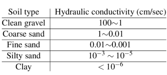
Hydraulic conductivity depends on size, shape and connectivity of the pores, which are largely determined by the soil texture and structure. For example, coarse soils like sand has large connected pores which allows water to pass through quickly. Thus, resulting in high conductivity. While fine soils like clay have discontineous connected pores which impending water movement, thus, leading to lower hydraulic conductivity.
Mathematically, hydraulic conductivity K is the ratio of flux to hydraulic gradient.
K= q/ dH/L = V/At * L/dH
q=Specific discharged rate or flux
L= distance or length
H= hydraulic head
dH= difference in hydraulic head (H1 – H2)
H1=inflow
H2=outflow
A= Cross sectional area
t= time
At high values, hydraulic conductivity indicate permeability of material through which water can pass easily while low hydraulic conductivity values indicate that the material is less permeable.
Hydraulic conductivity depends on the properties of the mineral materials and the permeate fluid passing through the pore spaces within the materials. This is because different types of soil or rock have different properties and behave differently if it is permeated by different fluids – for example water or hydrocarbons (oil). This makes the study of hydraulic conductivity a useful property of soil, because it clears the term related to the flow of water.
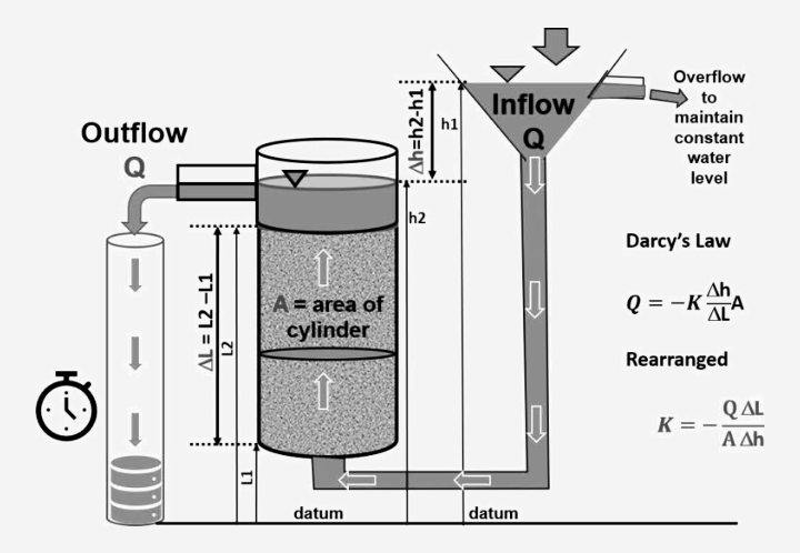
Hydraulic conductivity works based on the principle of Darcy’s law. It is a coefficient in Darcy’s law, which relates water flow velocity to hydraulic gradient under laminar flow conditions.
Hydraulic conductivity has thesame units with velocity, that is, metres/sec or metres/day.
DARCY’S LAW
The law states that the flow of liquid through a porous medium is in the direction of air at a rate proportional to the driven force acting on the liquid (hydraulic gradient =dH/L) and also proportional to the property of the conducting medium to transmit liquid (the conductivity)
EXPLAINING SATURATED AND UNSATURATED FLOW USING DARCY’S LAW
SATURATED FLOW: Darcy ‘s law says that if water flows in macroscopically uniform saturated soil body, the relationship of the flow rate, dimensions of the body and the hydraulic conditions (that is, viscosity, density etc) at inflow, outflow boundaries may be described quantitative as;
Note: Q is directly proportional to A
A is directly proportional to dH
and dH is directly proportional to 1/L
The flux q = – K (dH/L)
K= hydraulic conductivity
q= flux ( volume of water or liquid passing through a cross sectional area per time)
dH=difference in hydraulic head
L= lenght or distance
The negative sign indicate flow in the direction of decreasing potential.
UNSATURATED FLOW: Darcy Backingham uses his equation to describe unsaturated flow. It is calculated by introducing a simple proportionate constant which is a modified form of K factor in saturated condition.
Therefore, for unsaturated condition,
q= V/At = – K(dH/L). Saturated flow
Modified to
q= V/At = – K¶(dH/L) unsaturated flow
H = is the sum of potential ( matric and gravitational potential
¶= a dimentionless variable which is zero when the soil is naturally dry and 1 when the soil is saturated
K= saturated permeability or saturated hydraulic conductivity
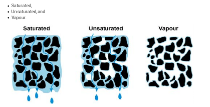
DIFFERENCES BETWEEN SATURATED AND UNSATURATED FLOW
The most important difference between saturated and unsaturated flow is the hydraulic conductivity. When the pores are highly saturated, the conductivity is at maximum. However, when the pore is unsaturated, all the pores become air filled and the conductivity portion of the soil cross sectional area decreases correspondilly.
Furthermore, as suctions(dryness) develops, the first pore to empty are the macropores living water to flow only in the smaller pores.
TYPES OF PERMEABILITY
Permeability differs from conductivity.
Permeability is ideally a property of the porous medium alone. While conductivity is the ability of the soil to transmitte fluid or water. Therefore, change in fluid properties such as viscosity and density will affect permeability.
Mathematically,
k= conductivity.
K = K§/Pg
§=viscosity
P=density
g=gravity
There are two types of permeability ;
Primary permeability and
secondary permeability.
PRIMARY PERMEABILITY
This occurs only in soil mass. The way water flows through the pores of a soil mass is referred to as ‘primary permeability’ or intergranular flow.
SECONDARY PERMEABILITY
This occurs in rocks. The principal way that groundwater flows in most fractured rocks is not through the spaces between the mineral particles forming the rock (the rock mass itself tends to have a very low hydraulic conductivity). Instead the water passes along fissures, fractures or discontinuities within the rock mass. This type of flow is referred to as ‘secondary permeability’ or fissure flow.
REASONS FOR MEASURING HYDRAULIC CONDUCTIVITY
Hydraulic conductivity impacts everthing the soil is used for. For example; crop production, irrigation and drainage, hydrology ( native and urban), Landfill performance (limiting the ability of water to move into the soil and also to store more water under the cover), storm water system design (measures the need of the soil and how they behave and measure more water under soil water), and soil health (measures soil ability to infiltrate water).
IMPORTANCE OF SOIL HYDRAULIC CONDUCTIVITY
1. Soil hydraulic conductivity impacts almost every soil application.
2. It is used to understand the complete water balance and is also used for estimating groundwater recharge through the vadose zone.
3. Hydrologists need hydraulic conductivity values for modeling
4. Researchers use it to determine soil health
5. It is used to predict how water will flow through soil at different field sites.
6. Agricultural decisions are based on hydraulic conductivity for determining irrigation rates or to predict erosion or nutrient leaching.
7. It is used to determine landfill cover efficacy.
8. Geotechnical engineers need it for designing retention ponds, roadbeds, rain gardens, or any system designed to capture runoff.
9. It is also used to understand plant available water in soilless substrates. Basically, it is used to predict how water will move within the soil system. Hydraulic conductivity governs water flow.
10. It is a key factor in determining the need for dewatering and groundwater control. For example, excavations below the groundwater level in a soil of high hydraulic conductivity will need more dewatering pumping than excavations in soil of low hydraulic conductivity
11. Hydraulic conductivity controls the rate of drainage of soil or rock, it has a significant impact on geotechnical stability problems (retaining walls, slopes, embankments, foundations).
12. Hydraulic conductivity controls the water-flow rate through soil and the time to ponding when water at the soil surface is partitioned between infiltration and runoff.
13. Hydraulic conductivity determines the speed and direction of water flow through the ground.
14. Farmers use hydraulic conductivity to optimize water application by understanding soil water transmission capabilities.
15. Engineers uses hydraulic conductivity to plan effective drainage systems and assess slopes stability accurately.
16. Students of environmental studies uses hydraulic conductivity to modelhow quickly contamination moves through soil to ground water.
FACTORS THAT INFLUENCE HYDRAULIC CONDUCTIVITY
Hydraulic conductivity is dependent on factors such as soil texture, particle size distribution, roughness, tortuosity, shape, soil structure, pore structure , bulk density, water content,/ potential ( for example, expansive soils), bioporesand degree of interconnection of water-conducting pores. For example,
1. In soil texture, coarse textured soils like sand do have higher hydraulic conductivities than fine-textured soils like clay.
2. Also, soil structure and pore structure can have a significant impact on a soil’s ability to transmit water. A structured soil typically contains large pores, while structureless soils have smaller pores.
3. Biopores, root channels, or animal burrows increase saturated hydraulic conductivity if they contain water. If they are not filled with water to the soil surface, they can decrease conductivity. 4. Compaction or the density of the soil is another influencing factor, as well as the water content or the water potential of the soil.
5. All properties of water can have an influence on hydraulic conductivity. The viscosity of water varies with temperature, so hydraulic conductivity will also vary with temperature.
6. Climate change, especially extreme events such as flood and drought, can change the soil structure and hence alter the speed at which water enters the soil and affect the partitioning.
7. K depend on the intrinsic permeability (k, unit: m2) of the material, the degree of saturation, and on the density and viscosity of the fluid.
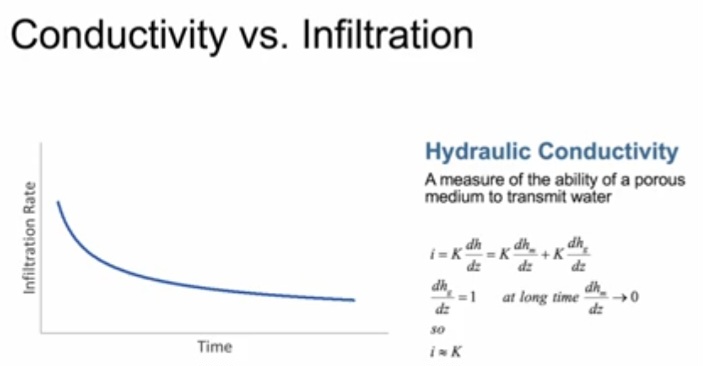
RELATIONSHIPS BETWEEN HYDRAULIC CONDUCTIVITY AND INFILTRATION
From the graph above, Ifiltration rate decreases with time. Measuring infiltration rate helps determine hydraulic conductivity of the soil.Infiltration rate can be used to measure hydraulic conductivity
HOW TO MEASURE HYDRAULIC CONDUCTIVITY
Hydraulic conductivity is not measured directly. It can be measured based on saturated soils and unsaturated soil
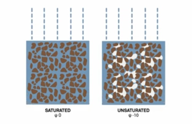
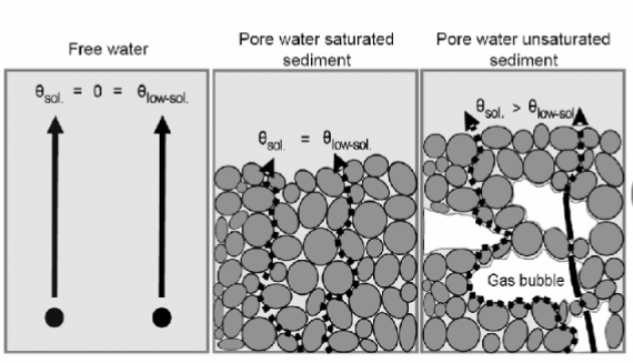
SATURATED SOIL WATER CONDITION ( Ψ0) AND UNSATURATED SOIL WATER CONDITION (Ψ10): This means there is more trapped air and the soil is not pulling on the water too much and also there is less channels in the soil that is contributing to the flow, meaning hydraulic conductivity in unsaturated condition is lower than saturated soil condition.
HOW TO MEASURE HYDRAULIC CONDUCTIVITY
Hydraulic conductivity is not measured directly. In reality, physical parameters (such as water levels or flow rates) are measured directly, and hydraulic conductivity is then calculated or interpreted. Obtaining realistic values of hydraulic conductivity is difficult.
Soil hydraulic conductivity can be measured in the field or in the laboratory. The preferred method is in the field because this is minimally invasive as it does not require the removal of a soil core.
Several different approaches can be taken to estimating hydraulic conductivity, they include:
Visual assessment – assessing the soil type or grading and, based on experience or published values, estimating an approximate range of hydraulic conductivity.
Particle size correlations – using empirical correlations to relate particle size distributions in granular soils to hydraulic conductivity.
Laboratory tests – permeameter testing on core samples.
Borehole tests – In-situ tests (rising head, falling head, constant head tests) carried out in boreholes during drilling or later in monitoring wells.
Pumping tests – controlled and carefully monitored pumping from one or more wells, recording drawdown in observation wells pumped flow rate.
TOOLS FOR MEASURING HYDRAULIC CONDUCTIVITYA.
A. EFFECT OF SOIL TEXTURE ON HYDRAULIC CONDUCTIVITY
Aim: TO DEMONSTRATE THAT SOIL TEXTURE IS NOT THE PRIMARY DETERMINANT OF HYDRAULIC CONDUCTIVITY.
The graph below shows infiltration curve for a clay soil
The graph shows infiltration curve for a poorly and well structured clayey soils and also infiltration capacity for structurelesa sandy soil.The curves in the graph reveals that;
1. How has soil conditions become unsturated and how does it change with hydraulic conductivity at different water potentials.
2. As the curve line gets closer to saturation, the structure of the soil starts playing a bigger role in the soils ability to retain water.
3. Well structured clay soil will infiltrate more water under unsaturated conditons than the structureless sandy soils.

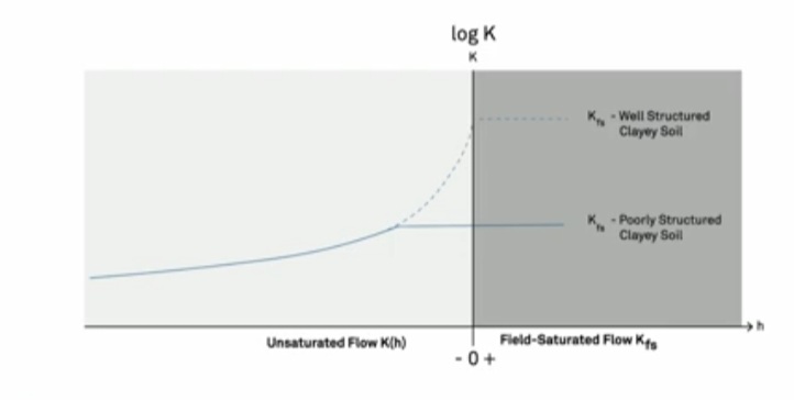
(Figure 8. Hydraulic conductivity curves for three different soils. Values to the right of the vertical axis indicate saturated conductivity values. Values to the left indicate unsaturated values. Note that the vertical axis is a logarithmic axis. Thus differences are order of magnitude differences (factors of 10, not factors of 1 or 2).
The vertical axis is at 0 head (water potential). Values to the right indicate saturated conductivity values. Values to the left indicate unsaturated values. The poorly structured clayey soil (lower line) has a saturated conductivity much lower than the sandy soil. This is because the clayey soil consists of small pores and the flow paths are more restricted. But, if that clayey soil (dotted line) had good structure (that is., it contained aggregates with large pores between those aggregates which created better flow paths) then its saturated hydraulic conductivity could be higher than the conductivity of the sand.
On the left side of Figure 8, where the head (water potential) is negative, the soil starts to desaturate, and the pores empty. As the pores (especially the large pores) empty, the hydraulic conductivity decreases dramatically. So, the unsaturated conductivity is always less, and in most cases, orders of magnitude less than it is when the soil is saturated.
Notice that the unsaturated hydraulic conductivity for the poorly structured clayey soil and the well structured clayey soil eventually meet. This is because at a certain point the macropores stop contributing to the flow, and then flow occurs only in the mesopores between the soil particles. Also note that the unsaturated hydraulic conductivity curve for the structureless sandy soil starts out higher than the clayey soil, but as the soil dries, the unsaturated hydraulic conductivity becomes lower than the clayey soils.)
From here, it can be deduced that soil texture is not the primary driver when it comes to hydraulic conductivity.
B. EFFECT OF SOIL STUCTURE ON HYDRAULIC CONDUCTIVITY
From the graph below ( Fig 8)
Aim: TO DEMONSTRATE THAT SOIL STEUCTURE HAS MASSIVE IMPACY ON HYDRAULIC CONDUCTIVITY

On the X axis, is the water potential. And on the Y axis is the hydraulic conductivity.
i. When the water potential value is positive, the soil is considered saturated and when negative, the soil is considered unsaturated.
Using a well structured clay soil to explain the graph: – Well structured clay soil means the soil has a large number of larger pores.
HOW HYDRAULIC CONDUCTIVITY CHANGES IN RELATION TO THE WATER POTENTIAL VALUE
When the water potential is negetive, the hydrauluc conductivity line is bearly straight but curved. When it reaches the saturated state,nthe hydraulic conductivity remains constant.
In conclusion, using structureless (sandy soil) and poor stuctured soil( clay soil), these two types of soils along with the well structured soil in the graph of fig 8 and 9, show that the structure of the soil has massive impact on Hydraulic conductivity.
DESCRIPTION OF HYDRAULIC CONDUCTIVITY USING HOMOGENEITY AND HETEROGENEITY
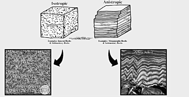
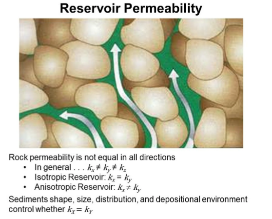
Hydraulic conductivity distribution can be described in terms of homogeneity (same throughout) or heterogeneity (variable from location to location) and having isotropic (at a location the same in all directions) or anisotropic (at a location not the same in all directions).
ISOTROPY AND ANISOTROPY
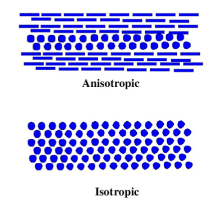
HYDRAULIC CONDUCTIVITY ISOTROPY
The hydraulic conductivity over a coefficient of consolidation ( CV) at any point in a medium can be either isotropic or anisotropic. The hydraulic conductivity isotropic implies that hydraulic conductivity values of a medium are independent of the direction. That is, water is transferred evenly in any direction. Mathematically, an isotropic hydraulic conductivity is a scalar, a quantity with magnitude but no direction.
HYDRAULIC CONDUCTIVITY ANISOTROPIC
Conversely, if the hydraulic conductivity over a coefficient of consolidation (CV) differs for different directions, the hydraulic conductivity of the CV is said to be anisotropic. That is, In soils with layered structure and with varying property, more water is transferred to a certain direction. For example, the hydraulic conductivity of the coefficient of consolidation (CV) measured in the horizontal direction may be greater or smaller than in the vertical. In general, a porous medium may be homogeneous and nevertheless anisotropic, or it may be heterogeneous and yet isotropic at each location. Under most field conditions, soils exhibit both heterogeneity and anisotropic.
RELATIONSHIPS BETWEEN ISOTROPIC, ANISOTROPIC WITH HOMOGENEOUS AND HETEROGENEOUS SOIL CONDITIONS
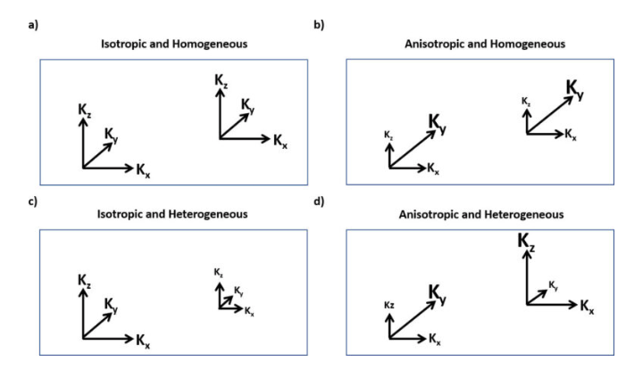
a) ISOTROPIC AND HOMOGENEOUS CONDITIONS : Graphically, the values of hydraulic conductivity in each coordinate direction are equal at all locations.
b) ANISOTROPIC AND HOMOGENEOUS CONDITIONS : one or more of the values of hydraulic conductivity in each coordinate direction are not equal, but this relationship is the same at all locations within the region.
c) ISOTROPIC AND HETEROGENEOUS CONDITIONS : hydraulic conductivity is equal in all directions at a location, but values differ at other locations.
d) ANISOTROPIC AND HETEROGENEOUS CONDITIONS : one of more of the directional values of hydraulic conductivity can differ at each location and they can all be different at each location.
METHODS FOR MEASURING HYDRAULIC CONDUCTIVITY
Hydraulic conductivity (K) can be measured using various methods. It can be measured using:
1. Laboratory tests (constant/falling head permeameters on core samples),
2. Field methods like infiltrometers (ring/double ring for above water table) or auger hole/pump tests (below water table), and
3. Empirical formulas. This is based on particle size, with the choice depending on soil type (sand vs. clay) and scale (laboratory sample vs. aquifer).
1. LABORATORY METHODS (PERMEAMETERS)
a. CONSTANT HEAD TEST: This is ideal for permeable soils (like sands and gravels). Here, water flows through a saturated sample at a steady rate under constant pressure. It measures flow rate and head difference.
CONSTANT HEAD PERMEAMETER (FOR PERMEABLE SOILS, (K>10^{-3}) cm/s)
This method works on the principle of steady flow with a constant head difference (h) across the sample. A reservior is setup where water flows from the reservoir, through the sample in a cylinder, and is collected at the outlet.
PROCEDURE:
-Prepare a saturated, undisturbed core sample (using porous stones/filters) in the permeameter. -Maintain a constant water level (head (h) by adjusting the outlet or overflow. -Measure the volume of water (Q) that flows through the sample in a specific time (t). -Calculate K using Darcy’s Law: K= frac{QL}{Aht}, where L is sample length, A is sample area, h is head, t is time, Q is volume.
b. FALLING HEAD TEST: This method is used for less permeable soils (like silts, clays). Here, the head drops over time as water flows through the sample. It measures head change over time in a standpipe.
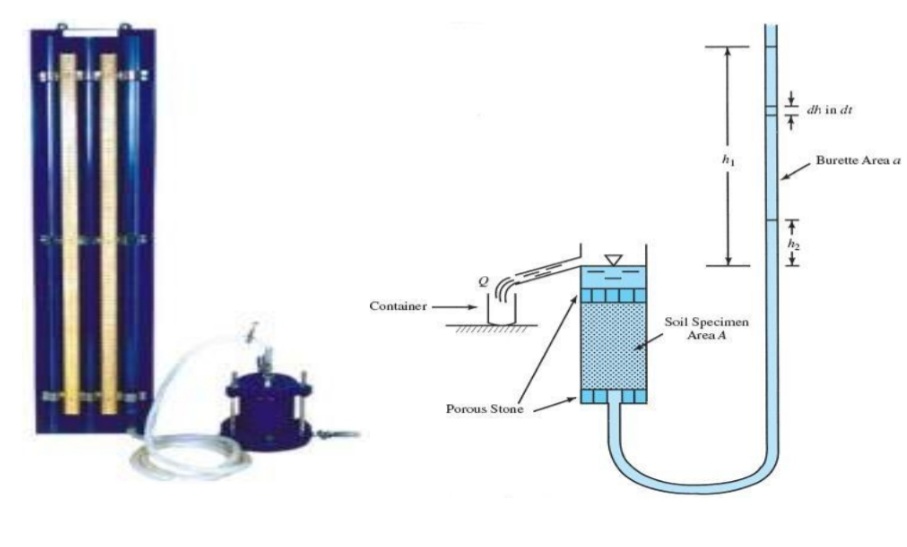
FALLING HEAD PERMEAMETER (FOR LESS PERMEABLE SOILS,(K<10^{-3}) cm/s)
This method works on the principle of unsteady- state flow where the head drops over time. A standpipe (burette) of known area (a) connected to the sample is used.
PROCEDURE:
-Saturate the core sample in the permeameter. -Let water flow from the standpipe through the sample. -Record the time (t) for the water level to drop from an initial height (h_{1}) to a final height (h_{2}). -Calculate K using the formula:(K= frac{aL}{At}\ln \left(frac{h_{1}}{h_{2}}right).
PRECAUTIONS WHEN USING THESE LABORATORY METHODS
1. The undisturbed sample is essential for representative results, often taken with core samplers. 2. In the case of saturation, the sample must be fully saturated and air bubbles must be removed completely. 3. Use grease/gaskets to prevent or seal up lateral water leakage around the core.
These laboratory methods uses permeameters with core samples, relying on Darcy’s Law principles, where K is determined by water flow rate, head loss, sample dimensions, and time. A constant or changing hydraulic head is applied across an undisturbed soil core and measure the resulting water volume or head drop over time, ensuring the sample is saturated and sealed to prevent leaks.
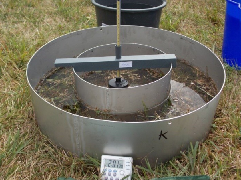
2. FIELD METHODS (IN-SITU)INFILTROMETERS: This method measures K above the water table. A ring is driven into the soil, and water is added at a constant or falling head, measuring infiltration.
TYPES OF FIELD METHOD
a. AUGER HOLE METHOD: This is ideal for saturated zones. Here, water is removed from a hole, and the rate of water level recovery is measured.
b. PUMPING TESTS: This is used for large aquifer volumes. Water is pumped from a well, and drawdown is measured in nearby observation wells to calculate K.
c. DOUBLE-RING INFILTROMETERS: A variation that minimizes lateral flow issues of single-ring tests, improving accuracy.
DIFFERENCES BETWEEN THE LABORATORY TEST AND FIELD TESTS
Laboratory tests are point samples and can differ from field values due to sample disturbance or inability to replicate natural stress/heterogeneity
3. EMPIRICAL FORMULAS: This method estimate K from soil properties like grain size distribution (for example, Hazen’s or Beyer’s formulas).
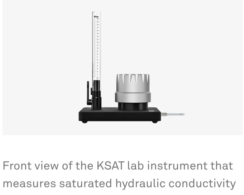
4. AUTOMATED SYSTEMS: Devices like KSAT and HYPROP automate lab/field measurements, generating data for unsaturated and saturated K curves.
TERMINOLOGIES
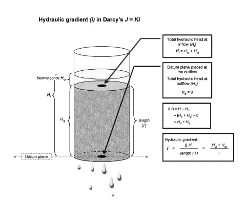
a. HYDRAULIC GRADIENT: This is the change in hydraulic head H per unit distance. That is head drop per unit distance in the direction of flow.
b. DISCHARGED RATE (Q) : This is the volume of water passing through a soil column per unit time.
Q= V/t
Q is directly proportional to A (Cross sectional area)
c. SPECIFIC DISCHARGE RATE (q) : It is also called water flux density. This is the volume of water passing through a given cross sectional area A per unit time. It has a unit of metres per seconds (m/s). It is also called flow velocity.
d. SOIL PERMEABILITY( k): This is the readiness with which soil can conduct water or other fluid.
e. PERMEABILITY AND CONDUCTIVITY: These are measures of the ability of the soil to conduct water or other fluids.
f. SATURATED FLOW: This is the transfer of liquid which takes place through a saturated soil medium
g. UNSATURATED FLOW: This is the transfer mechanism in which the liquid movement is a function of the degree to which the pores of the soils are filled with water. This flow can take place in liquid or vapour phase.
H. TORTOURSITY: This is the average ratio of the actual roundabout part to the apparent or straight flow of water or liquids.
Mathematically:
Tortoursity= roundabout path/ straight flow path